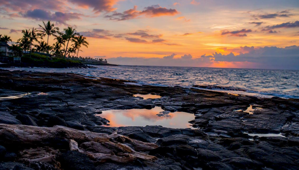
The Kona coast is the leeward dry western shoreline of Hawaiʻi Island, built by hotspot volcanism and sheltered from rain by the island's own towering peaks. What you see when you stand at the water's edge is mostly dark, wave-worn basalt, not the long sandy beaches you might picture. Perched pockets of white sand, anchialine pools glittering in the rock, and coral reef margins just offshore are the signature features here. Three places put the whole picture in sharp focus: the flanks of Mauna Loa rising behind you, the coastal bench at Puʻuhonua o Hōnaunau National Historical Park, and the fishpond-studded shore at Kaloko-Honokōhau National Historical Park.
The coast's most visible features at a glance:
- Basalt shore platforms — flat, wave-cut ledges of cooled lava that replace sandy beach along most of the shoreline
- Perched beaches — small, carbonate-sand pockets trapped in lava hollows, rare and precious
- Anchialine pools — landlocked brackish pools connected to the ocean through underground fissures in the lava
- Coral reef margins — shallow reef shelves just offshore, especially visible at Kealakekua Bay
- Coastal cliffs — vertical lava faces up to 30–37 meters high in places, particularly around Puʻuhonua o Hōnaunau
Key Takeaways
The Kona coast's geography is the direct result of hotspot volcanism, a trade wind rain shadow, and thousands of years of lava cooling into the basalt bench that defines the shoreline today.
| Point | Details |
|---|---|
| Leeward rain shadow | "Kona" means dry/leeward; trade winds leave the west coast very dry compared to other parts of the island. |
| Volcanic origins | Mauna Loa, Kīlauea, and Hualālai built the coastal bench through successive lava flows spanning thousands of years. |
| Basalt platform dominance | Most of the shoreline is cooled pahoehoe lava; sandy beaches are rare, small, and perched in lava hollows. |
| Anchialine pools | Landlocked brackish pools connected to the ocean through lava fissures host endemic species and are extremely fragile. |
| Cultural geography | Ahupuaʻa land divisions, fishponds, and sacred sites at Puʻuhonua o Hōnaunau, Kaloko-Honokōhau, and Puʻukoholā Heiau are tied directly to the coast's physical layout. |
Visit the NPS parks at Kaloko-Honokōhau and Puʻuhonua o Hōnaunau for the most accessible field observation of every major feature described here.
Table of Contents
- 1. Where exactly does the Kona coast begin and end?
- 2. How did the Kona coast form? Volcanoes, lava, and deep time
- 3. What does the Kona shoreline actually look like?
- 4. Why is Kona so sunny and dry compared to the rest of the island?
- 5. How does freshwater work on a lava coast?
- 6. What lives along the Kona coast?
- 7. How did Hawaiian culture shape and use this coastline?
- 8. What natural hazards should you know about on the Kona coast?
- 9. How to see and interpret Kona's geography in the field
- 10. A local perspective from the Kona foothills
- Why Kona's geography is worth understanding before you visit
- Sources
1. Where exactly does the Kona coast begin and end?
"Kona" refers to the entire western flank of Hawaiʻi Island, the Big Island, and it splits administratively into two districts: North Kona and South Kona. North Kona runs roughly from the Kohala coast boundary down through Kailua-Kona, the region's commercial hub. South Kona continues southward through Captain Cook, Kealakekua, and Hōnaunau, ending near the South Point area. Together, the two districts cover well over 100 miles of coastline.
The towns along this stretch each serve as a distinct access point to the coast's geography. Kailua-Kona is the urban center, with the harbor, shops, and the famous Ironman finish line on Ali'i Drive. Captain Cook and Kealakekua sit upslope in South Kona, perched in the cooler, greener coffee belt above the dry coastal bench. Hōnaunau is the gateway to Puʻuhonua o Hōnaunau National Historical Park, one of the most geologically and culturally rich stretches of the entire coast.
Elevation shifts fast here. Kailua-Kona sits near sea level, but the terrain climbs to hundreds of meters within just a few miles inland. That rapid gain is exactly what creates the dramatic climate and vegetation bands you notice on any drive up the mountain.
2. How did the Kona coast form? Volcanoes, lava, and deep time
Kona exists because the Pacific Plate has been moving slowly over a stationary mantle hotspot for millions of years. Each time the plate shifted, a new shield volcano built up from the seafloor, eventually breaking the surface and adding land. The Kona coast is the leeward flank of that process, shaped by successive lava flows that poured down the western slopes and cooled into the bench you walk on today.
Three volcanoes did most of the work:
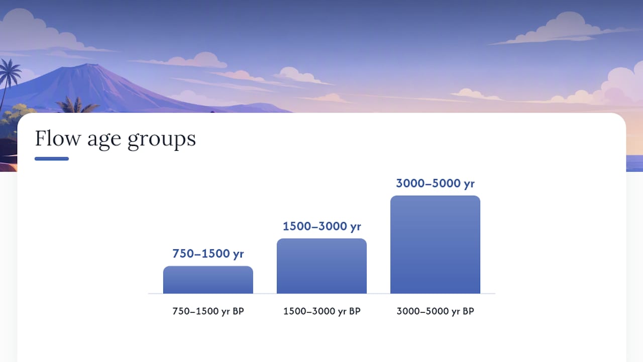
- Mauna Loa — the dominant force behind the Kona coast's southern and central sections. Its long, gentle western flank flows created the broad basalt bench that underlies parks like Puʻuhonua o Hōnaunau. USGS mapping identifies three major flow-age groups within the park alone: roughly 750–1,500 years BP, 1,500–3,000 years BP, and 3,000–5,000 years BP. Mauna Loa remains one of the most active volcanoes on Earth.
- Kīlauea — primarily active on the island's eastern rift zones, but its eruptions have historically contributed lava that reaches the coast. Its ongoing activity keeps the island geologically young and reminds visitors that this landscape is still being written.
- Hualālai — the volcano directly behind Kailua-Kona and the northern Kona parks. Its flank flows underlie Kaloko-Honokōhau National Historical Park and Puʻukoholā Heiau National Historic Site. Hualālai last erupted in 1801, and its lava bench forms the rocky shoreline you see along the northern Kona coast.
Two lava types define what you feel underfoot. Pahoehoe is smooth, ropy, and often forms the flat coastal platforms where turtles haul out and tide pools collect. ʻAʻā is rough, clinkery, and sharp-edged, the kind that makes off-trail walking genuinely painful. The underlying rock throughout is Kau Basalt, the geologic formation that makes up the bulk of Mauna Loa's younger flows and gives the Kona coast its characteristic dark, iron-rich appearance.
3. What does the Kona shoreline actually look like?
Rugged basalt platforms and small pockets of perched sand are the default. Long, continuous sandy beaches are rare on the Kona coast; most of the shoreline is cooled pahoehoe lava bench, wave-cut and wave-polished over centuries. When you do find sand, it is usually trapped in a lava hollow or sheltered cove, not a broad open beach.
Here is what each major landform looks like and where to find it:
- Basalt shore platforms — wide, flat ledges at or just above the waterline, formed where wave action has eroded the lava surface. The platform at Puʻuhonua o Hōnaunau is a textbook example: broad, dark, and dotted with tide pools.
- Perched beaches — small carbonate-sand beaches sitting in lava depressions, like Keoneʻele Cove inside Puʻuhonua o Hōnaunau. The sand here is made of broken coral and shell, not eroded rock.
- Coastal cliffs — vertical lava faces where the bench drops sharply to the ocean. Cliffs of 30–37 meters appear along the Puʻuhonua o Hōnaunau shoreline, carved by wave undercutting over thousands of years.
- Anchialine pools — one of the Kona coast's most unusual features. These are landlocked pools of brackish water sitting in lava depressions, connected to the ocean through underground fissures. They host specialized shrimp and invertebrates found almost nowhere else. Kaloko-Honokōhau National Historical Park protects several of the best examples on the island.
- Fishponds — ancient Hawaiian aquaculture structures built along the shore, using lava walls to trap fish. Kaloko Fishpond at Kaloko-Honokōhau is one of the largest and best-preserved on the island.
- Reef shelves — shallow coral reef margins just offshore, particularly prominent at Kealakekua Bay, where the reef supports some of the clearest water and richest marine life on the coast.
Pro Tip: If you want to see a perched beach versus a basalt platform side by side, Puʻuhonua o Hōnaunau gives you both within a short walk. The contrast between the dark lava ledge and the white sand cove is one of the most photogenic spots on the Big Island.
4. Why is Kona so sunny and dry compared to the rest of the island?
The word "Kona" itself means leeward or dry side in Hawaiian, and the name is a perfect description. Prevailing northeasterly trade winds carry moisture from the ocean and drop it when they hit the island's windward (eastern) slopes. By the time that air crosses the summit and descends on the western side, it has lost most of its moisture. The Kona coast sits in that rain shadow, sheltered behind Mauna Loa and Hualālai.
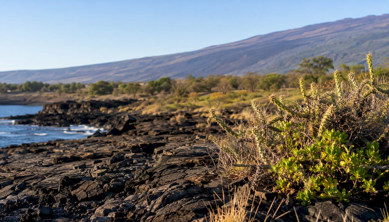
The numbers tell the story clearly. USGS park precipitation data shows just how dry the coastal bench really is:
Rainfall increases as you move inland and upslope, where orographic lifting kicks in again on the upper mountain slopes. The coffee farms around Captain Cook and Kealakekua, sitting at higher elevations, receive significantly more rain than the coast directly below them.
The exception to all this sunshine is a Kona storm. These are distinct weather events that occur when the prevailing trade wind pattern temporarily reverses. West-origin moisture flows in from the open ocean, bringing heavy rain, strong winds, and large waves to a coast that is normally sheltered. Kona storms are most common in winter and can catch visitors off guard precisely because the coast is so reliably dry the rest of the year.
5. How does freshwater work on a lava coast?
Kona's steep, porous lava fields limit surface water retention. Rain that falls on the upper slopes soaks quickly through fractured basalt rather than running off into streams. That permeability is both a challenge and a resource: freshwater concentrates in localized aquifers deep within the volcanic rock, and recharge rates vary significantly depending on elevation and rainfall zone.
Key points about Kona's hydrology:
- Aquifer recharge happens primarily in the wetter upslope zones; the dry coastal bench receives too little rainfall to recharge meaningfully on its own.
- Perched water tables can form where less permeable lava layers trap groundwater at intermediate elevations, sometimes creating springs or seeps that emerge at the coast.
- Saltwater intrusion is a real concern at the coastal margin, where the freshwater lens floating above denser seawater can be compromised by over-extraction or sea-level rise.
- Groundwater modeling for Kona uses thermal infrared and aeromagnetic surveys to map subsurface structure and freshwater-saltwater boundaries, tools that support both conservation planning and water resource management.
Pro Tip: Watch for patches of unusually lush, green vegetation right at the shoreline. Those spots often mark where a freshwater seep or spring is meeting the coast, a subtle sign of the aquifer system working its way to the surface. Anchialine pools are the most dramatic version of this, where you can actually see the brackish water sitting in the lava.
6. What lives along the Kona coast?
Kona's nearshore systems include coral reef habitat, shallow benthic zones, and fragile anchialine pools that host specialized species. Sea turtles are a regular presence in nearshore coves, and the reef communities here are among the healthiest on the Big Island.
Key habitats and what you will find in each:
- Coral reef margins — shallow reefs just offshore support a full community of Hawaiian reef fish, including wrasses, surgeonfish, and parrotfish. Kealakekua Bay is the standout site, with exceptional water clarity and coral cover protected partly by its status as a State Marine Life Conservation District.
- Shallow benthic zones — the rocky seafloor just inside the reef line, mapped in detail by USGS and NOAA SHOALS lidar surveys for the Kailua-Kona nearshore area. These surveys reveal the platform geometry and reef shelf structure that shapes fish habitat and snorkeling conditions.
- Anchialine pools — home to the endemic Hawaiian shrimp ʻōpaeʻula (Halocaridina rubra) and other invertebrates that exist nowhere else on Earth. These pools are connected to the ocean through underground lava tubes and are extremely sensitive to contamination, introduced species, and physical disturbance.
- Sea turtle habitat — green sea turtles (honu) haul out on the basalt platforms and rest in shallow coves throughout the Kona coast. The coastal bench at Puʻuhonua o Hōnaunau is a well-known resting site.
- Coastal scrub and dryland vegetation — on land, the arid coastal bench supports native dryland plants adapted to low rainfall and salt spray, though invasive species pressure is significant throughout the region.
The NPS-managed parks at Kaloko-Honokōhau and Puʻuhonua o Hōnaunau provide critical protection for anchialine pools, fishponds, and turtle habitat. Without that federal oversight, the combination of coastal development and visitor pressure would put these habitats under serious stress.
7. How did Hawaiian culture shape and use this coastline?
Kona's physical layout shaped traditional ahupuaʻa management systems, coastal fishponds, canoe landings, and sacred sites now preserved as National Park units. The ahupuaʻa was a wedge-shaped land division running from the mountain summit to the sea, designed so each community had access to every resource zone: upland forest, agricultural slopes, coastal fisheries, and open ocean. The Kona coast's geography made this system work beautifully, with distinct elevation bands offering different resources within a short vertical distance.
Named parks and cultural sites along the coast:
- Puʻuhonua o Hōnaunau National Historical Park — a place of refuge where Hawaiians who broke kapu (sacred law) could seek sanctuary. The park sits on a pahoehoe bench at the base of Mauna Loa and preserves a royal canoe landing, fishponds, and carved ki'i (temple images). The NPS site description details the coastal bench habitat and cultural features.
- Kaloko-Honokōhau National Historical Park — protects Kaloko Fishpond, one of the largest ancient fishponds on the island, along with anchialine pools and coastal trails that trace the old Hawaiian shoreline path.
- Puʻukoholā Heiau National Historic Site — a massive stone temple built by Kamehameha I in 1790–1791 on a lava bench above the ocean in North Kona. Its location was chosen deliberately for its commanding view of the coast and its access to the sea.
- Kealakekua Bay — the site of Captain Cook's arrival and death in 1779, and a place of deep cultural significance to Native Hawaiians. The bay's protected waters and the cliffs above it are tied to traditional fishing and navigation routes.
Pro Tip: When you visit any of these sites, stay on marked trails, keep your distance from fishponds and anchialine pools, and follow all NPS signage. These landscapes are not just scenic, they are living cultural records. Treating them with care is part of experiencing them honestly.
8. What natural hazards should you know about on the Kona coast?
Kona faces volcanic hazards, episodic Kona storms, and a documented tsunami and large-wave history that, together with gradual sea-level rise, shape coastal change and hazard planning across the region.
Hazards to be aware of:
- Volcanic activity — Mauna Loa and Kīlauea are both active. Mauna Loa's most recent significant eruption was in 2022, sending lava flows toward Saddle Road. Hualālai, directly above Kailua-Kona, last erupted in 1801 but is considered dormant, not extinct.
- Kona storms — when trade winds reverse, the normally sheltered coast gets hit with west-swell waves and heavy rain. These events can produce dangerous shore conditions with little warning.
- Tsunamis — the Kona coast has a documented tsunami history. The 1946 and 1960 Pacific tsunamis caused damage along the Big Island's coastline, and Kailua-Kona sits within mapped inundation zones. NOAA tide and forecast data for the Kona area provides real-time conditions and is the first place to check before any coastal activity.
- Wave hazards — even on calm days, unexpected large waves can sweep across basalt platforms. The flat, wet rock offers no grip and no warning.
- Erosion and sea-level rise — the low coastal bench is vulnerable to gradual inundation and storm surge. Perched beaches are particularly at risk, as the sand that fills lava hollows can be stripped away by a single large swell event.
For current hazard information, check NOAA's tide and forecast pages and the Hawaii Emergency Management Agency before heading to the coast.
9. How to see and interpret Kona's geography in the field
The best single-day route to sample Kona's geography starts at a shoreline park, moves to a reef or anchialine pool site, then climbs upslope to experience the climate and vegetation shift firsthand.
A suggested field itinerary:
- Morning: Kaloko-Honokōhau National Historical Park (North Kona) — arrive early to walk the coastal trail. Look for the basalt platform, Kaloko Fishpond, and anchialine pools. Notice how flat and dark the lava bench is at sea level. The USGS/NOAA lidar mapping of this nearshore area reveals the shelf geometry you are standing on.
- Midday: Kealakekua Bay — snorkel the reef or take a kayak out from the Captain Cook monument landing. The water clarity here is exceptional, and the reef shelf drops away clearly from the shallow bench. The cliffs above the bay show the lava stratigraphy in cross-section.
- Afternoon: Puʻuhonua o Hōnaunau National Historical Park — walk the coastal platform, visit the perched beach at Keoneʻele Cove, and look for turtles resting on the lava. The contrast between the smooth pahoehoe bench and the vertical coastal cliffs is most dramatic here in afternoon light.
- Late afternoon: Drive upslope through Captain Cook — a 15-minute drive from the coast takes you from arid scrub to coffee farms and dense vegetation. That shift is the orographic rain shadow in action, visible in real time.
Safety and etiquette reminders:
- Never stand on the edge of basalt platforms, especially when waves are running. The rock is slippery and the drop is sudden.
- Anchialine pools are extremely fragile. View them from the trail, never wade in or introduce anything.
- Follow all NPS signage at park sites. Restrictions exist to protect both the landscape and you.
- Check NOAA forecasts before any coastal activity, particularly in winter when Kona storms are possible.
For sustainable tour options that cover these sites with knowledgeable local guides, there are several operators on the Big Island who specialize in geology and cultural history.
10. A local perspective from the Kona foothills
From the hillside above Kealakekua Bay, the geography of the Kona coast makes immediate, physical sense. You can watch the arid coastal bench stretch north and south, dark and flat, while the slopes behind you turn green within a few hundred meters of elevation. The trade winds arrive from the northeast most mornings, and on clear days you can see the shadow line where the moisture stops and the dry zone begins. That visual transition, from scrub and lava at the shore to coffee trees and ferns upslope, is the rain shadow made visible.
A few local observations worth keeping in mind:
- Best sunrise vantage — the upper slopes above Captain Cook face east across the island's interior, and the light hits the mountain before it reaches the coast. Pastel colors over Mauna Loa at dawn are a genuine reward for early risers.
- Best sunset vantage — the coastal bench and any west-facing overlook above Kealakekua Bay. The sun drops into the open Pacific, and the light on the lava turns the platform from black to copper.
- Anchialine pools — visible from the trail at Kaloko-Honokōhau, but please stay on the path. The pools look like simple puddles from a distance; up close, they are complex ecosystems that took thousands of years to develop.
- Perched beach vs. platform — Puʻuhonua o Hōnaunau gives you both within a short walk of each other, the clearest side-by-side comparison on the coast.
- Conservation note — the freshwater constraints on this coast are real. Every visitor who respects the land, stays on trails, and avoids disturbing pools and fishponds is contributing to the long-term health of a landscape that cannot easily repair itself.
Luana inn sits in the foothills above Kealakekua Bay, right in the transition zone between the dry coastal bench and the wetter upland coffee belt. If you want to plan an oceanview retreat that puts you close to all of these geographic features, the location is genuinely hard to beat.
Why Kona's geography is worth understanding before you visit
Seeing the Kona coast as a geologic and cultural system, not just a scenic backdrop, changes how you experience it. The dark lava under your feet is not just rock; it is the record of eruptions that happened within living memory of Hawaiian ancestors who built fishponds and temples on the same bench. The dry air and bright sun are not just good weather; they are the rain shadow of a 13,000-foot volcano doing exactly what it has always done.
That connection between land, sea, and culture is what makes this stretch of coastline genuinely worth slowing down for. Walk the platforms, look for the pools, and take the drive upslope. The geography will tell you the rest.
Sources
These are the primary sources behind the geology, climate, and park descriptions in this article. All are federal or peer-reviewed resources with direct relevance to the Kona coast:
- Kona District, Hawaii — Wikipedia
- Geology of Puʻuhonua o Hōnaunau National Historical Park | U.S. Geological Survey
- Geologic resource evaluation of Puʻuhonua O Hōnaunau National Historical Park, Hawai'i; Part I, geology and coastal landforms | U.S. Geological Survey
- Puʻuhonua O Hōnaunau National Historical Park — NPS
- Digital image mosaics of the nearshore coastal waters of Kailua‑Kona — USGS/NOAA data catalog
These sources are authoritative because they come from federal monitoring networks (NOAA, USGS) and the National Park Service, agencies with direct management responsibility for the Kona coast's geology, hydrology, and cultural resources.