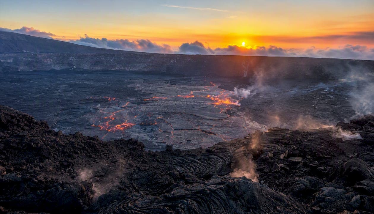
Hawaii's volcanic landscape is an active, living archipelago built by a stationary hotspot beneath a moving Pacific Plate, and the Big Island is still growing right now. The USGS Hawaiian Volcano Observatory and Hawaiʻi Volcanoes National Park are your two most reliable guides to understanding what you're looking at and staying safe while you look.
- Hotspot origin: A deep mantle plume, fixed in place, punches through the Pacific Plate to build each island as the plate drifts northwest.
- Active vs. dormant: Kīlauea and Mauna Loa are among the most active volcanoes on Earth; Mauna Kea and Hualālai are dormant but not extinct.
- Top safety habit: Check USGS and NPS alerts before every visit. Conditions change overnight.
Key Takeaways
Hawaii's volcanic landscape is built by a stationary hotspot beneath a moving Pacific Plate, making the Big Island the youngest and most active part of a 3,700-mile chain.
| Point | Details |
|---|---|
| Hotspot origin | A fixed mantle plume built the Hawaiian–Emperor seamount chain; islands get older moving northwest from the Big Island. |
| Active volcanoes | Kīlauea and Mauna Loa are among the most active on Earth; Kīlauea's episode 52 produced fountains reaching roughly 500 feet. |
| Key hazards | Vog, Pele's hair, lava crust collapse, and ground cracking persist even when visible lava is absent. |
| Ecological richness | Volcanic soils and rainfall gradients create rapid biodiversity transitions from coast to summit over just a few miles. |
| Cultural respect | Pele and the ahupuaʻa system are living cultural frameworks; follow NPS site rules and leave offerings undisturbed. |
Table of Contents
- How did the Hawaiian hotspot build an entire island chain?
- What types of volcanoes and lava features will you see in Hawaii?
- Which volcanoes built the Big Island?
- How do eruptions reshape the land, and what hazards should you know?
- How does volcanic activity create such rich, diverse ecosystems?
- Why does cultural context matter when you visit volcanic places?
- How do you experience volcanic Hawaii safely and responsibly?
- How this guide was put together
- A local perspective on volcano country
- Sources
How did the Hawaiian hotspot build an entire island chain?
The hotspot model is the key to understanding Hawaiian volcanic formations. A plume of superheated rock rises from deep in Earth's mantle and stays essentially stationary while the Pacific Plate slides northwest at roughly 2–4 inches per year. The result is a chain of volcanic islands and submerged seamounts stretching about 3,700 miles, called the Hawaiian–Emperor seamount chain. Think of it as a conveyor belt: the hotspot punches up through the plate, builds a volcano, and then the plate carries that volcano away from the heat source until it goes quiet and slowly sinks.
Age progression along the chain confirms the model. Islands and seamounts get progressively older the farther northwest you travel from the Big Island. The University of Hawaiʻi's Hawaii Center for Volcanology documents this sequence clearly: Kauai, in the northwest of the main island group, is geologically old, while the Big Island's youngest lava flows are geologically brand new. The Big Island sits directly over the hotspot today, which is why Kīlauea and Mauna Loa are still erupting while Kauaʻi's volcanoes went cold long ago.
What types of volcanoes and lava features will you see in Hawaii?
Every volcano in Hawaii is a shield volcano, shaped by highly fluid basaltic lava that spreads wide and far before cooling. National Geographic explains that this fluidity is exactly why Hawaiian volcanoes have those broad, gently sloping profiles rather than the steep, explosive cones you'd see in the Cascades. The lava doesn't trap gas the same way, so eruptions tend to produce flows rather than catastrophic blasts.
Here are the key landforms and lava types you'll encounter:
- Pāhoehoe: Smooth, ropy lava that cools into glossy, undulating sheets. Safe to walk on when cold, but deceptively fragile at the surface.
- ʻAʻā: Rough, jagged, clinkery lava. Slow-moving but sharp enough to shred boots. Wear sturdy footwear.
- Caldera: A large summit depression formed when magma drains from beneath and the roof collapses. Halemaʻumaʻu crater inside Kīlauea's caldera is the most visited example.
- Rift zone: A crack in the volcano's flank where magma rises and erupts laterally. Kīlauea's East Rift Zone has produced some of its most dramatic flows.
- Lava tube: A hardened lava tunnel left behind when the outer crust cools and the molten interior drains out. Thurston Lava Tube (Nāhuku) in the national park is a popular walk-through.
- Tephra and Pele's hair: Fine volcanic glass threads and ash ejected during fountaining events. Pele's hair can travel miles on the wind and irritates skin and lungs on contact.
Which volcanoes built the Big Island?
The Big Island is actually five overlapping shield volcanoes at different stages of life, plus a sixth still forming underwater. NPS confirms that Kīlauea and Mauna Loa rank among the most active volcanoes on Earth, while the others range from dormant to extinct.
| Volcano | Summit Elevation | Activity Status |
|---|---|---|
| Mauna Loa | 13,679 ft | Active (erupted 2022) |
| Mauna Kea | 13,796 ft | Dormant |
| Kīlauea | 4,091 ft | Active (ongoing episodic eruptions) |
| Hualālai | 8,271 ft | Dormant (last erupted 1801) |
| Kohala | 5,480 ft | Extinct (oldest on the island) |
| Lōʻihi | Submarine (~3,200 ft below sea level) | Active (future island forming) |
Kīlauea is the star of current activity, with episodic eruptions centered in Halemaʻumaʻu crater. Mauna Loa, the largest active volcano on Earth by volume, last erupted in November 2022. Lōʻihi, the submarine volcano growing southeast of the Big Island, is the hotspot's newest project and won't breach the surface for tens of thousands of years.
How do eruptions reshape the land, and what hazards should you know?
Eruptions both build and repeatedly alter the landscape, and many hazards persist even when visible lava is absent. USGS Kīlauea updates document this vividly: during episode 52, lava fountains reached roughly 500 feet and eruption plumes rose to about 19,000 feet above sea level, scattering tephra and Pele's hair across a wide area. The eruption was episodic, meaning intense bursts followed by pauses, which is exactly the pattern visitors need to plan around.
Before and during your visit, follow these steps:
- Check the USGS Kīlauea updates page for current eruption status and hazard zones.
- Review NPS park closures and trail conditions at the Hawaiʻi Volcanoes National Park site.
- Check the vog forecast at IVHHN (International Volcanic Health Hazard Network) before heading out, especially if you have respiratory sensitivities.
- Stay on marked trails and inside designated viewing areas. Crater rims and lava benches can collapse without warning.
- Wear a dust mask or N95 if vog or Pele's hair is present. Bring eye protection on windy days near active areas.
- Never enter closed zones, even briefly. Lava crust over active tubes can be inches thick.
Pro Tip: Use the USGS webcam feeds, updated continuously, to gauge current activity before you drive to a viewing area. A quiet morning on the webcam can turn active by afternoon, so check again right before you leave.
How does volcanic activity create such rich, diverse ecosystems?
Fresh basalt weathers into a mosaic of soils that, combined with elevation and rainfall gradients, produces some of the most compressed biodiversity on the planet. CTAHR's soil research shows that volcanic parent material, elevation, and rainfall combine to create rapid transitions from fertile lowland soils to acidic, highly weathered soils at high elevation, all within a few miles of each other.
The ecological gradient on the Big Island runs roughly like this:
- Coastal and low-elevation zones: Young, thin soils with sparse pioneer plants. Sparse rainfall on the leeward side keeps vegetation minimal.
- Mid-elevation slopes: Richer soils, higher rainfall, dense native forest with ʻōhiʻa lehua and tree ferns (hāpuʻu). This is where succession on older lava flows is most visible.
- High-elevation cloud forest and summit: Acidic, heavily leached soils. Sparse, specialized vegetation gives way to barren lava and cinder above the cloud line.
Succession on fresh lava starts with pioneer mosses and ferns colonizing cracks where windblown organic matter collects. Over decades, ʻōhiʻa trees establish, and the forest slowly rebuilds. Human impacts have accelerated soil loss and introduced species pressure, which is why restoration researchers recommend blending modern science with traditional Hawaiian land management to restore productive, resilient landscapes.
Why does cultural context matter when you visit volcanic places?
Pele, the Hawaiian deity of volcanoes and fire, and the ahupuaʻa land system are the two cultural pillars that shape how Hawaiians relate to volcanic terrain. Pele is not a myth to set aside at the trailhead. She is an active presence in Hawaiian culture, and the land you're walking on is considered sacred by many Native Hawaiians.
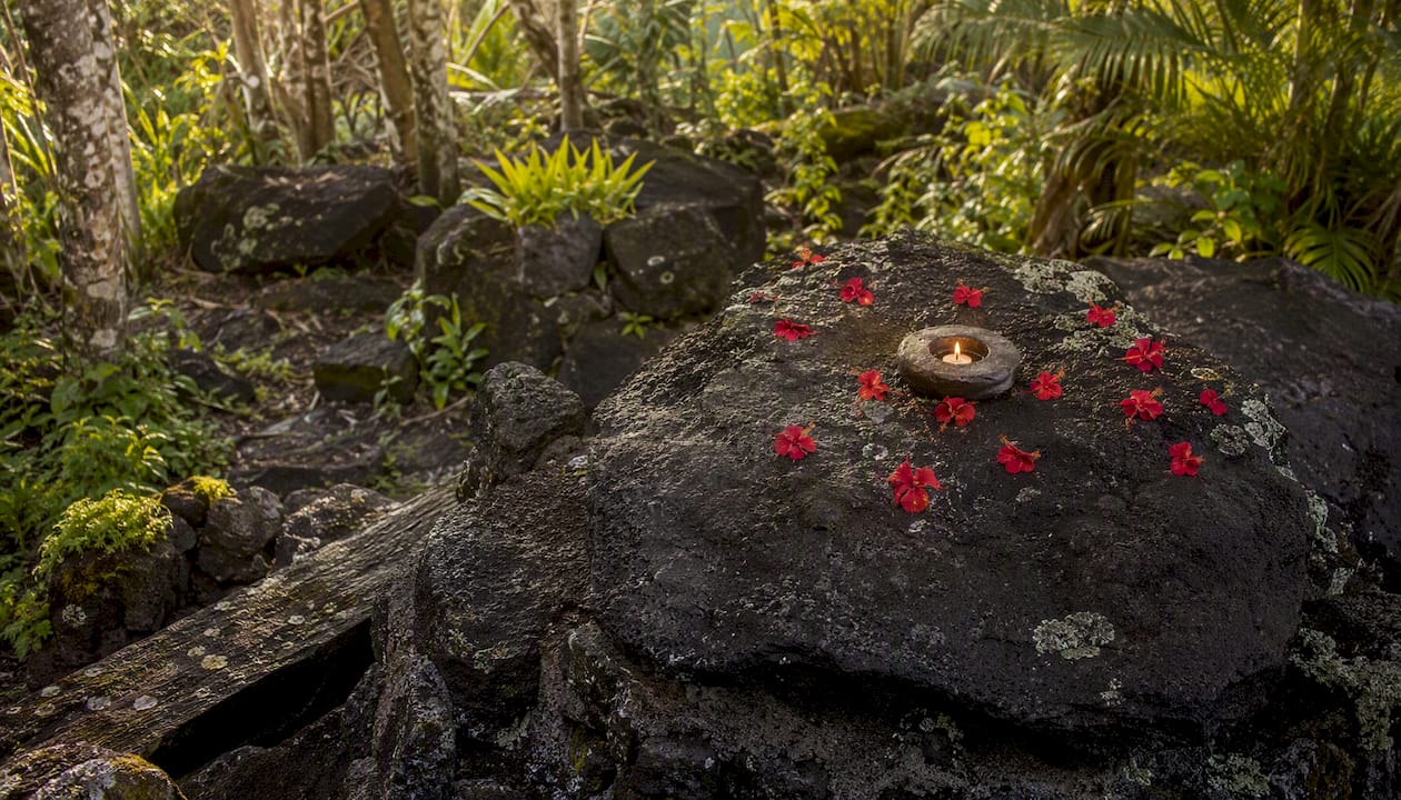
The ahupuaʻa is a traditional land division running from mountain summit to ocean reef, managing water, agriculture, and fisheries as one integrated system. Upland watershed health directly affected coastal productivity. That vertical logic still guides modern restoration and explains why protecting high-elevation forest matters for coastal communities downstream.
For respectful visitation, keep these in mind:
- Leave any natural offerings or lei you find at trailheads and overlooks exactly where they are.
- Learn the Hawaiian names for the places you visit. Using them is a small act of respect that matters.
- Do not remove rocks, lava, or sand. Beyond the cultural significance, it is illegal in the national park.
- Follow posted site rules without exception. They reflect both safety and cultural stewardship.
- For deeper context, the NPS cultural resources pages and the Bishop Museum in Honolulu are excellent starting points.
For a broader guide to visiting respectfully, the Hawaii cultural etiquette guide covers the dos and don'ts in practical detail.
How do you experience volcanic Hawaii safely and responsibly?
The single best planning habit is checking USGS and NPS updates before you leave your accommodation, every single day. Conditions shift fast. A trail open yesterday may be closed this morning.
Your pre-trip checklist:
- USGS Kīlauea and Mauna Loa alert pages for eruption status
- NPS Hawaiʻi Volcanoes National Park for trail and road closures
- IVHHN vog forecast for air quality
- Weather forecast for summit areas (temperature drops sharply with elevation)
Pack sturdy, closed-toe shoes with ankle support for lava fields. Bring a dust mask or N95, sunscreen, plenty of water, and a light wind breaker. For high-elevation visits to Mauna Kea, add warm layers and allow time to acclimatize to altitude.
Guided tours led by local naturalists offer the safest and most informative experience, especially for first-time visitors to active areas. Self-guided visits to official NPS overlooks are perfectly accessible, but stay on marked paths. The Big Island bucket list guide highlights responsibly run experiences worth adding to your itinerary. For packing specifics, the Hawaii B&B packing list covers vog masks, layering for elevation, and footwear in one place.
How this guide was put together
This guide draws on USGS Hawaiian Volcano Observatory data, NPS Hawaiʻi Volcanoes National Park guidance, peer-reviewed soil and ecology research from the University of Hawaiʻi CTAHR extension, and local observation from Luana inn's position in the foothills of Mauna Loa above Kealakekua Bay. Eruption status changes daily, sometimes hourly, so the sources below are the ones to check for live conditions.
A local perspective on volcano country
Living and hosting guests in the foothills of Mauna Loa gives you a different relationship with this landscape than a day-trip visitor gets. You wake up to the mountain's silhouette changing color at sunrise. You notice when the air carries a faint sulfur edge and know to check the vog forecast before planning an outdoor morning. That daily awareness is what I'd most want to pass on to visitors.
My single practical tip: go early. Lava viewing and high-elevation walks are best in the first hours after sunrise, before afternoon clouds build and before vog concentrations rise with the heat of the day. Book your accommodation close enough to the park that an early start is easy, not heroic.
Luana Inn sits on Napoʻopoʻo Road above Kealakekua Bay, about an hour from Hawaiʻi Volcanoes National Park, with sunset views over the ocean and cool mountain air at night. It's a genuinely comfortable base for volcano country. If you're planning a stay, the Luana Inn vacation packages pair local experiences with the kind of rest that makes a full day on lava fields feel manageable.

Sources
Eruption status changes daily, so bookmark these pages and check them before every outing.
- Evolution of the Hawaiian volcanoes (U.S. Geological Survey - HVO)
- Volcanoes - Hawaiʻi Volcanoes National Park (NPS)
- Kīlauea volcano updates (U.S. Geological Survey)
- Soil diversity across Hawaiian landscapes (CTAHR extension bulletin)
- Hawaii volcanoes, explained (National Geographic)